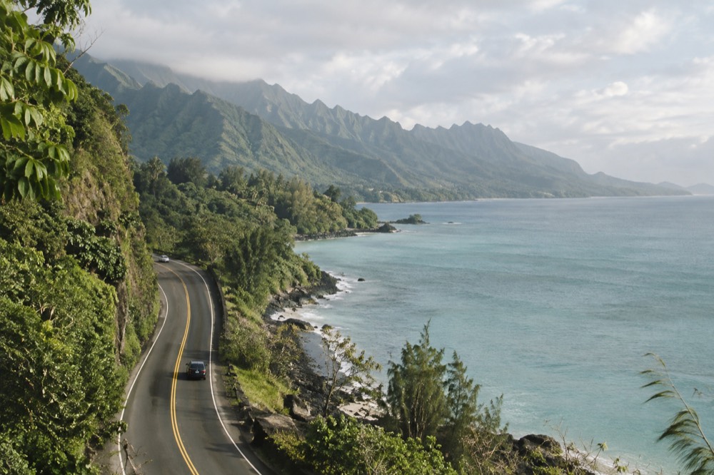
Kaʻena Point State Park On Oʻahu: What A Visit Actually Involves
Kaʻena Point is the wild, roadless tip of Oʻahu, reachable only on foot along an old railroad bed from either the Waiʻanae side or the North Shore side. It is a sacred site, a seabird sanctuary behind a predator-proof fence, and, as of September 2026, partially closed for storm repairs.
Short answer
Kaʻena Point State Park is a roadless coastal reserve at Oʻahu's westernmost tip, reached by hiking the kaena point trail from Mokulēʻia on the north or Keawaʻula on the south. As of 9 September 2026 the Mokulēʻia and Keawaʻula sections are closed until further notice for Hurricane Lowell repairs, so check the DLNR notices before planning a visit.
Kaʻena Point is the westernmost tip of Oʻahu, and no road reaches it. The state park that protects the point wraps around both sides of the island's end, and the only way in is on foot, along the old railroad grade locals call the kaena point trail. What waits at the end is one of the last intact coastal dune ecosystems in the main Hawaiian Islands, a predator-proof fence guarding nesting seabirds, and a shoreline where Hawaiian monk seals haul out. It is also, in Hawaiian tradition, a leina a ka ʻuhane, a place where souls depart the living world, which is why this guide treats it with more restraint than your average beach hike.
There is one thing to get out of the way immediately. As of 9 September 2026, the DLNR State Parks notice lists Kaʻena Point State Park (Mokulēʻia and Keawaʻula sections) as closed until further notice for repairs after Hurricane Lowell. This is a live situation. Everything below tells you how the park works when it is open, because it will reopen, but verify the current status on the DLNR State Parks notices page before you drive out.
What Is Kaʻena Point State Park?
Kaʻena Point State Park is a roadless coastal reserve protecting the westernmost tip of Oʻahu, managed by Hawaii DLNR as two sections approached from opposite sides of the island. The Mokulēʻia section is reached from the North Shore; the Keawaʻula section, including the popular Keawaʻula beach, is reached from the Waiʻanae coast. The point itself sits inside the Kaʻena Point Natural Area Reserve.
That reserve designation matters more than the state park line on the map. The Natural Area Reserve, managed with the DLNR Division of Forestry and Wildlife, covers the point and the dune system seabirds depend on, and it adds the predator-proof fence plus stricter wildlife rules to the walking access the state park sections provide.
The park exists because the road stops. The highway from either direction ends at a gate, and beyond that gate the coastline reverts to what most of Oʻahu looked like before development: raw dunes, ironwood shade, tide pools and a shoreline that has never had a hotel or a parking structure.
Two things make the place culturally significant. First, Kaʻena is a leina a ka ʻuhane in Hawaiian tradition, a recognized leaping place of souls, and it deserves the same quiet you would give any sacred site: stay on the trail, do not stack or move stones, do not walk into roped or fenced areas. Second, the predator-proof fence across the dunes is a working conservation structure, not a photo prop. It keeps rats, mongooses, dogs and cats away from ground-nesting birds, and the Laysan albatross colony inside it is one of very few in the main islands.
If you want the fuller picture of the coast the trail runs through, our leeward coast guide covers the Waiʻanae side and our North Shore Oʻahu guide covers the approach from Haleʻiwa.
Is The Kaʻena Point Trail Open Right Now?
As of 9 September 2026, no. The DLNR State Parks notice lists Kaʻena Point State Park, both the Mokulēʻia and Keawaʻula sections, as closed until further notice following Hurricane Lowell. The same notice closed Nuʻuanu Pali State Wayside and Wahiawā Freshwater State Recreation Area, while every other Oʻahu state park had reopened. Storm-damaged reservation refunds are being processed automatically and take roughly four to six weeks.
That closure is the single most important planning fact on this page, and it is the reason we will not dress this section up. The trail itself is an exposed coastal route with no water, no shade beyond scattered ironwoods and no cell coverage at the far end, so storm damage to the route is a genuine safety issue, not bureaucratic caution. DLNR reopens sections as repairs finish, and the notices banner on their site is the only source that counts.
| Site (Oʻahu) | Status as of 9 Sept 2026 | Source |
|---|---|---|
| Kaʻena Point SP, Mokulēʻia section | Closed until further notice | DLNR notices banner |
| Kaʻena Point SP, Keawaʻula section | Closed until further notice | DLNR notices banner |
| Nuʻuanu Pali State Wayside | Closed until further notice | DLNR notices banner |
| Wahiawā Freshwater SRA | Closed until further notice | DLNR notices banner |
| Other Oʻahu state parks | Reopened post-storm | DLNR notices banner |
If your dates are fixed and the point is still shut, the honest move is to hike something else and save Kaʻena for a return trip. Diamond Head is open and requires a reservation for out-of-state visitors, and a guided option bundles the ticket and shuttle so you are not wrestling the booking system yourself.
How Do You Reach The Kaʻena Point Trail?
You reach the trail from one of two sides, and both are dead ends. From the North Shore, the road ends at the Mokulēʻia gate beyond Dillingham Airfield, giving access along the old railroad grade toward the point. From the Waiʻanae side, the road ends past Keawaʻula, where a dirt track continues along the coast. There is no through route and no loop.
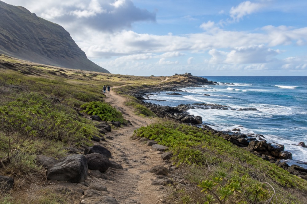
You walk out and back on whichever coast you started from, and no road connects the two sides. Both approaches share the same character: a flat, sun-blasted walk on loose gravel and sand over the old rail bed, with the ocean in view the entire way. The north side feels more remote and gets the winter surf; the south side is the one most day visitors pick because Keawaʻula, a long curving beach, sits near the trailhead and makes an easy pairing with the walk. Neither approach has facilities beyond the trailhead, so water, sunscreen and a hat are not optional.
A few practical cautions that come straight from the park's own rules rather than from other blogs. Gates must be closed behind you, because the fence only works if people respect it. Dogs are not welcome in the reserve sections, for the same reason. Drones are prohibited in Hawaii State Parks without a written permit, so leave the camera drone at the hotel. And the dunes on either side of the trail are not a shortcut: burials are present in dune and shoreline areas across Oʻahu, often unmarked, and disturbing them is both illegal and deeply offensive.
While the point is closed, hikers looking for a coastal-adjacent walk on the windward side have alternatives, and a self-guided rainforest option covers the Mānoa Falls route with transport sorted.
How Much Does It Cost To Visit Kaʻena Point?
The trail has carried no entry fee in normal times, and Hawaii residents have never paid for state park entry at Kaʻena, but confirm current conditions on the DLNR page because storm closures can change access rules. What costs money is the getting there: this is the far end of the island from Waikīkī, so the real price is a rental car day, fuel and most of your afternoon.
Kaʻena's access rules have shifted with the closure, and the DLNR page is the only source that reflects today's reality. Diamond Head charges out-of-state visitors per person and per vehicle, card only. Hanauma Bay charges a non-resident entry fee plus a service fee and closes Mondays and Tuesdays. Kaʻena, historically, has been free to enter, and if that changes the DLNR page will say so first. The full index of guides sits on Oahu Travel Guide.
The other "cost" is timing. Plan it as a half-day commitment minimum, and pair it with something else on whichever coast you choose rather than making it a standalone dash.
| Item | What to expect |
|---|---|
| Entry fee | No fee historically; confirm on the DLNR page given current closures |
| Facilities | None beyond trailheads; carry all water and food |
| Shade | Minimal; scattered ironwoods only |
| Cell coverage | Unreliable at the point |
| Dogs | Not permitted in the reserve sections |
| Drones | Prohibited in state parks without a written permit |
| Best pairing | Keawaʻula beach (south side) or a North Shore loop |
If the closure has knocked Kaʻena off your list for this trip, the island's open hikes and scenic tours are the sensible substitute, and the three below are the ones we would point a displaced hiker toward first.
Each of those options is running now, takes bookings online and can be sorted in a few minutes, which is more than can be said for a trail with a storm-damage closure on it. If you want the closest thing to a guaranteed-good morning out of Waikīkī while the west end recovers, the guided Diamond Head option is the one to check first.
What Will You Actually See On The Kaʻena Point Trail?
The trail delivers three things in order: a long walk on the old railroad grade, the predator-proof fence and its gate at the dune line, and then the point itself, where Laysan albatross nest on the ground, Hawaiian monk seals haul out on the sand, and winter months bring humpback whales passing offshore. The shoreline is rocky and powerful, the dunes are off-limits to walking, and the sense of remoteness is real because the road genuinely ends.
The birds are the reason the fence exists. Wedge-tailed shearwaters nest in burrows, and Laysan albatross, birds that spend most of their lives over open ocean, raise chicks here at ground level. That makes the reserve one of the few places in the main Hawaiian Islands where you can watch an albatross on land, and it also makes your behaviour consequential: stay on the path, keep the gate closed, and give any bird on the ground a wide berth.
Monk seals are the other headline. If one is hauled out on the beach, the guidance is 50 feet of distance, 150 for a mother with a pup, and those are recommended distances rather than statutory ones. What is law is the prohibition on take and harassment, which protects seals under federal and state statutes. Humpback whales, by contrast, carry a hard legal number: 100 yards, from boats and swimmers alike, and the sanctuary season runs November through April.
| Animal | Distance to keep | Law or guideline |
|---|---|---|
| Humpback whale | 100 yards | Law |
| Hawaiian spinner dolphin | 50 yards, no swim-with | Law |
| Hawaiian monk seal | 50 ft; 150 ft mother and pup | Guideline, but harassment is illegal |
| Green sea turtle (honu) | 10 ft | Guideline, but protected |
And the cultural weight of the place bears repeating here, because the wildlife and the sacredness sit in the same few acres. Kaʻena is a leina a ka ʻuhane. Walk the trail the way you would walk through a cathedral, take your photographs from the path, and leave every stone exactly where it is.
When Is The Best Time To Hike Kaʻena Point?
Go early, go in the cooler half of the year, and watch the surf forecast rather than the rain forecast. The trail is fully exposed, so midday heat is the main physical constraint, and the shoreline at the point is dangerous in high surf, which on this coast peaks in summer. Winter brings humpback whales offshore between November and April.
The leeward side is one of the driest corners of the island, so rain rarely ruins the plan. The rainfall numbers make the point plainly. NOAA's 1991-2020 normals put Honolulu airport at 16.41 inches of rain a year, the driest station in our dataset, while the Mānoa valley station, five miles from Waikīkī, records 150.96 inches. Kaʻena sits on the same dry leeward system as the airport side of the island. You plan around sun and heat here, not around rain.
Surf is the second timing factor. The National Weather Service's Oʻahu surf forecast publishes by shore aspect, and the west-facing shore near Kaʻena runs larger in summer than winter. High surf on a rocky shoreline means spray, surge and closed tide pools; check the forecast the morning you go, and never turn your back on the water at the point itself.
Is The Kaʻena Point Trail Worth The Trip From Waikīkī?
It is worth it for one specific kind of visitor: the person who wants Oʻahu's wild, roadless coastline and is willing to spend half a day, in full sun, walking a flat gravel trail to get it. It is not worth it if you want a payoff view or something you can see in an hour, because the reward is remoteness and wildlife rather than spectacle.
Families with small children, anyone heat-sensitive, and cruise passengers on a tight clock should choose differently. The honest comparison is with the island's other big hikes. Diamond Head gives you a crater rim and a panorama in a couple of hours, and it is why it is Oʻahu's most-booked walk. Mānoa Falls gives you rainforest and a waterfall. Kaʻena gives you neither of those things; it gives you albatross, monk seals, and the strange quiet of a coastline with no road. If that sentence appeals to you, the drive is justified. If it does not, no amount of Instagram will change your mind at kilometre two.
For visitors who want scenic payoff with the logistics handled, a half-day lookouts tour covers seven viewpoints with a guide and transport, which suits anyone who would rather not spend their holiday behind a steering wheel.
One more planning thought. Because the point sits at the end of two coasts, it pairs naturally with a day on either side: Haleʻiwa and the North Shore towns from the Mokulēʻia end, or the Waiʻanae coast from Keawaʻula. Doing Kaʻena as part of a full circle-island day is also common, though it makes for a long day of driving. Our best Oʻahu day trips guide lays out how to sequence the west end with stops along the way.
Common Questions About Kaʻena Point State Park
Most questions about Kaʻena Point come down to four things: the closure status, the two trailhead approaches, the lack of facilities, and the wildlife rules at the far end. The park is free to enter when open, reachable only on foot, closed entirely as of September 2026 for storm repairs, and strict about dogs, drones and staying on the trail. Everything below restates those points in the terms people actually ask.
Is Kaʻena Point State Park open?
Not as of 9 September 2026. The DLNR State Parks notice lists the Mokulēʻia and Keawaʻula sections as closed until further notice following Hurricane Lowell. Check the DLNR notices page before you plan, as sections reopen as repairs complete.
How do I get to the Kaʻena Point trailhead?
From the north, follow the road past Dillingham Airfield on the Mokulēʻia coast until it ends at a gate. From the south, follow the Waiʻanae coast road past Keawaʻula. Both are dead ends with no connection between them; you walk out and back on the side you choose.
Is there a fee for Kaʻena Point?
The trail has historically carried no entry fee, but confirm on the DLNR page given the current closure. The real cost of a visit is the travel time and a rental car day, since the point is as far from Waikīkī as Oʻahu allows.
Can you see monk seals and albatross at Kaʻena Point?
Yes, when the park is open. Hawaiian monk seals haul out on the beaches and Laysan albatross nest on the ground inside the predator-proof fence. Keep at least 50 feet from seals, 150 from a mother and pup, stay on the trail and close the fence gates behind you.
Are dogs allowed on the Kaʻena Point trail?
No. Dogs are not permitted in the reserve sections because they are a threat to ground-nesting seabirds, the very reason the predator-proof fence exists.
How hard is the Kaʻena Point hike?
The route is flat, on gravel and sand over an old railroad bed, but it is fully exposed with no water and little shade. The difficulty is heat and distance rather than climbing, so start early and carry more water than you think you need.
Kaʻena Point rewards exactly the kind of visitor it has always rewarded: the one who reads the rules, carries the water and walks quietly through a place that matters. Check the closure notice, pick your coast, and give the point the respect it is owed.